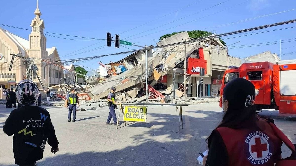
At least 35 dead, over 200 injured after powerful Mindanao earthquake
At least 35 people have been killed and more than 200 injured after a magnitude 7.8 earthquake struck off the coast of Sarangani in the southern Philippines, triggering tsunami warnings, widespread damage, and more than 1,100 aftershocks.
- At least 35 people were killed and more than 200 injured in the magnitude 7.8 earthquake.
- Tsunami waves were recorded across several Mindanao coastal areas before warnings were lifted.
- More than 1,100 aftershocks have been recorded as rescue and relief operations continue.

At least 35 people have been killed and more than 200 injured after a powerful magnitude 7.8 earthquake struck off the coast of Maasim, Sarangani, in the southern Philippines on Monday morning, triggering tsunami warnings, damaging infrastructure, and disrupting essential services across Mindanao.
Authorities said the death toll could rise further as search-and-rescue operations, damage assessments, and relief efforts continue in affected areas.
The earthquake occurred at 7:37 a.m. local time, with its epicentre located offshore near Maasim in Sarangani Province. Strong shaking was felt across much of Mindanao, particularly in the Soccsksargen region, Davao areas, and parts of the Bangsamoro Autonomous Region in Muslim Mindanao.
The quake caused significant damage to buildings, roads, power facilities, and communication networks.
Emergency officials reported widespread power outages and interruptions to transport services in several provinces. Rescue teams were deployed to damaged communities as authorities worked to assess the full extent of the destruction.
In General Santos City, one of the urban centres closest to the epicentre, structural damage was reported in commercial establishments and public buildings. Video footage circulating online showed portions of buildings collapsing during the earthquake.
Local authorities ordered inspections of government offices, schools, and other structures before allowing public access.
Schools had resumed classes for the new academic year on Monday when the earthquake struck. Following the disaster, classes were suspended in affected areas. The Philippine Red Cross reported assisting students and school personnel at several educational institutions impacted by the quake.
Tsunami warnings and coastal evacuations
The earthquake also generated tsunami waves along parts of Mindanao's coastline. According to the Philippine Institute of Volcanology and Seismology (Phivolcs), tsunami activity was recorded in six coastal locations, including Maasim and Kiamba in Sarangani, Kalamansig in Sultan Kudarat, Mati City in Davao Oriental, Zamboanga City, and Tandag City in Surigao del Sur.
The highest recorded tsunami wave reached approximately 1.4 metres above normal tide levels.
Phivolcs initially issued tsunami warnings covering several coastal provinces, including Sarangani, Davao Occidental, South Cotabato, Sultan Kudarat, Basilan, Sulu, Tawi-Tawi, Zamboanga del Sur, and Zamboanga Sibugay. Residents in vulnerable coastal communities were instructed to move immediately to higher ground.
The Philippine Coast Guard suspended watercraft operations in parts of southern Mindanao, including fishing, passenger, and commercial vessels, while evacuation and coastal monitoring operations were carried out.
The tsunami warning was lifted later on Monday after sea-level conditions gradually returned to normal.
More than 1,100 aftershocks recorded
Seismic activity continued throughout Monday and into Tuesday.
Phivolcs reported that the number of aftershocks had reached approximately 1,100 by 8 am on Tuesday. The aftershocks ranged in magnitude from 1.3 to 6.7, indicating ongoing movement along the fault system responsible for the earthquake.
Of the recorded aftershocks, 313 were plotted by state seismologists and 23 were felt by residents. The strongest aftershock measured magnitude 6.7 and was felt across several parts of Mindanao.
Authorities warned that aftershocks could continue for weeks and potentially more than a month. Residents were advised to avoid entering damaged buildings and to remain prepared for additional strong tremors.
Emergency response under way
The Office of Civil Defense, local government units, the Armed Forces of the Philippines, the Philippine Coast Guard, and humanitarian organisations have been mobilised to assist affected communities.
Civil Defense officials identified Regions 9, 11, and 12, along with the Bangsamoro Autonomous Region in Muslim Mindanao, as among the areas most affected by the disaster.
President Ferdinand Marcos Jr. directed national agencies and members of the National Disaster Risk Reduction and Management Council to support ongoing rescue, evacuation, and relief operations. Government teams have been conducting rapid assessments to determine infrastructure damage, identify isolated communities, and coordinate humanitarian assistance.
Tsunami observed in Indonesia
The earthquake's impact extended beyond the Philippines.
Indonesia's Meteorology, Climatology and Geophysics Agency (BMKG) reported small tsunami waves along parts of northern and eastern Indonesia. Measurements showed sea-level anomalies ranging from 9 to 19 centimetres at several coastal monitoring stations in North Sulawesi and North Maluku.
The highest wave recorded in Indonesia reached 0.19 metres in Melonguane, located in the Talaud Islands. Authorities maintained monitoring operations throughout the morning before lifting tsunami warnings later in the day.
Ongoing assessments
Emergency officials continue to assess the full impact of the earthquake, particularly in remote and coastal communities where communication and transportation links remain disrupted.
With more than 1,100 aftershocks already recorded and rescue operations continuing across Mindanao, authorities have warned that casualty figures and damage estimates are likely to change as additional information becomes available.
The Philippines, located along the Pacific Ring of Fire, is among the world's most seismically active countries and regularly experiences major earthquakes and volcanic activity. Monday's magnitude 7.8 earthquake ranks among the strongest seismic events to affect the southern Philippines in recent years.