Multiple Indonesian volcanoes erupt as authorities issue renewed warnings
Mount Ile Lewotolok, Mount Ibu and Mount Semeru erupted across Indonesia from late 28 May into 29 May, prompting safety warnings over ashfall, lahars and pyroclastic hazards.
- Mount Ile Lewotolok, Mount Ibu and Mount Semeru erupted between 28 and 29 May.
- Authorities warned residents about ashfall, lahars and pyroclastic cloud hazards near the volcanoes.
- Mount Semeru remains Indonesia’s most active volcano with more than 1,100 eruptions recorded this year.

Several volcanoes across Indonesia erupted from late Thursday into early Friday, prompting renewed safety warnings from the country’s volcanology agency as activity continued in East Nusa Tenggara, North Maluku and East Java.
The Centre for Volcanology and Geological Hazard Mitigation, known locally as PVMBG, recorded eruptions at Mount Ile Lewotolok, Mount Ibu and Mount Semeru between the night of 28 May and the early hours of 29 May.
The three volcanoes are located in different parts of the Indonesian archipelago, where volcanic activity is closely monitored through observation posts and the MAGMA Indonesia reporting system.
Mount Ile Lewotolok, in Lembata Regency, East Nusa Tenggara, erupted at 11.17pm local time on Thursday. Officers observed an ash column rising about 100 metres above the summit. The volcano itself stands 1,523 metres above sea level.
The ash column was reported to be white to grey, with thick intensity, and was moving towards the south-east. The eruption was recorded on a seismogram with a maximum amplitude of 19 millimetres and a duration of 36 seconds.
“Incandescent material was ejected within the summit radius,” an observation officer said in a statement issued on Friday.
Mount Ile Lewotolok remains at Level II, or alert status. PVMBG has prohibited public activity within a two-kilometre radius of the eruption centre.
Authorities also warned of the possible danger of lava avalanches, landslides and pyroclastic clouds in the southern and south-eastern sectors, as well as in the western and north-eastern sectors.
The latest eruption followed repeated activity throughout Thursday. According to officers at the Ile Lewotolok Volcano Observation Post, the mountain erupted 19 times during the 24-hour observation period from midnight to midnight on 28 May.
The eruptions produced ash columns between 100 and 200 metres high, accompanied by white and grey smoke.
Yeremias Kristianto Pugel, an officer at the observation post, said the eruptions were accompanied by incandescent material and a weak rumbling sound. Seismogram data showed amplitudes of 11.1 to 59.7 millimetres and durations of around 31 to 71 seconds.
During the same observation period, monitoring equipment also detected two harmonic tremor earthquakes, one multiple-phase earthquake, four deep volcanic earthquakes, one local tectonic earthquake and three distant tectonic earthquakes.
PVMBG urged residents, visitors and tourists not to enter the restricted zone. Communities around Mount Ile Lewotolok were also advised to wear masks and other protective equipment to protect the mouth, nose, eyes and skin from volcanic ash. Residents were asked to cover clean-water reservoirs to prevent ash contamination.
Shortly after midnight, Mount Ibu in North Maluku also erupted. The eruption occurred at 12.10am Eastern Indonesia Time on Friday.
According to PVMBG data cited through the MAGMA Indonesia application, the ash column reached around 600 metres above the summit, which stands 1,925 metres above sea level.
The ash column was white to grey, with moderate to thick intensity, and moved towards the north-east. The eruption was still continuing when the initial report was prepared.
The event was recorded on a seismogram with a maximum amplitude of 20 millimetres and a duration of 55 seconds.
Mount Ibu, located on Halmahera Island, is also at Level II, or alert status. PVMBG has banned activity within a two-kilometre radius of the volcano and within a sectoral extension of 3.5 kilometres towards the crater opening in the northern part of the active crater.
Over the past week, Mount Ibu has erupted 25 times, according to Databoks, which cited PVMBG eruption data through MAGMA Indonesia.
In its volcanic activity report, seismic monitoring also recorded eruption earthquakes, emission earthquakes and harmonic earthquakes.
Authorities urged communities, visitors and tourists to stay outside the danger zone and to follow official instructions from observation officers.
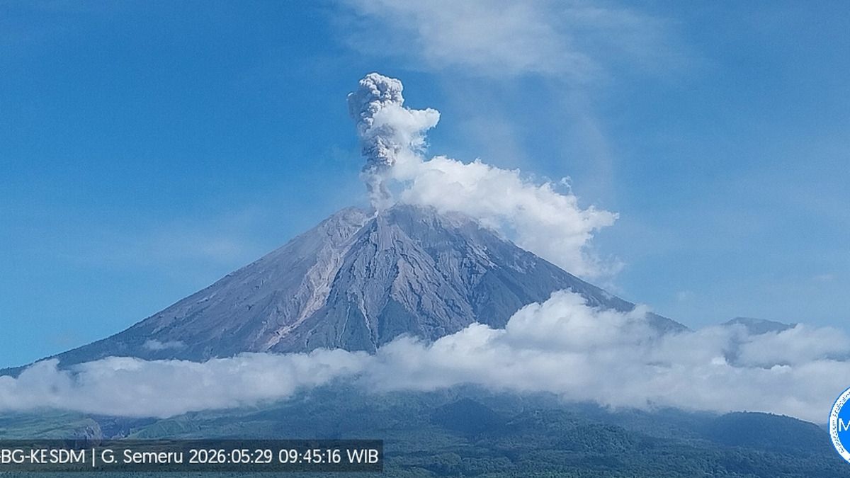
Mount Semeru, in Lumajang Regency, East Java, erupted at 12.33am Western Indonesia Time on Friday. Officers observed an ash column rising about 700 metres above the summit of the 4,376-metre volcano.
The ash column was white to grey, thick in intensity, and drifted towards the north and north-west.
The eruption was recorded on a seismogram with a maximum amplitude of 22 millimetres and a duration of two minutes and 39 seconds.
Semeru’s activity remained elevated later on Friday. The Semeru Volcano Observation Post reported that the mountain erupted 21 times between 6am and midday Western Indonesia Time.
Ash columns were observed rising between 500 and 1,000 metres above Jonggring Saloko Crater.
“An eruption of Mount Semeru occurred on Friday, 29 May 2026, at 9.43am Western Indonesia Time, with the observed ash column reaching 1,000 metres above the summit,” Mukdas Sofian, an officer at the Semeru observation post, said in a written statement.
Mount Semeru is currently at Level III, or standby status. PVMBG has recommended that no activity be carried out in the south-eastern sector along Besuk Kobokan up to 13 kilometres from the summit.
It has also prohibited activity within 500 metres of the riverbank along Besuk Kobokan because of the potential for pyroclastic clouds and lahar flows extending up to 17 kilometres from the summit.
Authorities have also warned the public not to carry out activities within a five-kilometre radius of Semeru’s crater or summit because of the risk of ejected rocks and incandescent material.
Other hazards include pyroclastic clouds, lava avalanches and lahars along rivers and valleys originating from the summit, especially Besuk Kobokan, Besuk Bang, Besuk Kembar and Besuk Sat.
Smaller rivers that feed into Besuk Kobokan are also considered at risk of lahar flows.
The head of the Lumajang Regional Disaster Management Agency, Insugroho, said there had been no immediate reports of damage or casualties from the latest eruption.
However, he said ashfall could occur in parts of Malang Regency because eruption smoke had been carried by winds towards the north-west.
He also warned that heavy rain around Mount Semeru could trigger lahar floods, carrying volcanic material that has accumulated on the slopes after repeated eruptions and avalanches.
“In terms of the number of eruptions, it is still high. This could trigger lahar floods carrying a considerable amount of material if heavy rain occurs around the mountain,” Insugroho said.
Indonesia monitors volcanic activity through PVMBG and MAGMA Indonesia, with eruption reports issued for residents, local governments and aviation authorities.
A Databoks report based on MAGMA Indonesia data recorded 2,198 volcanic eruptions nationwide from 1 January to 28 May 2026, with Mount Semeru accounting for the highest number at 1,105 eruptions by that date.
A later local report put the 2026 nationwide total at 2,205 eruptions, with Mount Semeru recording 1,109 eruptions and Mount Ibu 803.
The figures underline the frequency of volcanic activity being reported across the country, although the hazard level differs from one volcano to another.
Indonesia sits along the seismically active Pacific “Ring of Fire” and has a long history of volcanic eruptions and earthquakes.
Mount Semeru, the highest volcano on Java Island, has erupted frequently in recent years, including a major eruption in 2021 that killed 51 people and displaced thousands