Mindanao earthquake kills 16, triggers tsunami waves in Philippines and Indonesia
At least 16 people have been reported dead and more than 200 injured after a magnitude-7.8 earthquake struck near Mindanao, damaging buildings, disrupting schools and prompting tsunami warnings across parts of the Philippines, Indonesia and Malaysia.
- At least 16 people were reported dead and more than 200 injured after the earthquake.
- Tsunami waves were detected in multiple locations across the Philippines and Indonesia.
- Authorities suspended classes, launched evacuations and warned of ongoing aftershock risks.

16 people have been reported dead after a powerful earthquake struck the southern Philippines on Monday morning, damaging buildings, prompting tsunami warnings and causing small tsunami waves to be detected along parts of Indonesia’s northern and eastern coastline.
The latest reported toll was higher than earlier accounts that put the number of deaths at at least 15.
The earthquake, measured by several agencies at magnitude 7.8, struck near Mindanao at 7.37am local time.
The Philippine Institute of Volcanology and Seismology, or Phivolcs, placed the epicentre offshore near Sarangani province, while the US Geological Survey also reported a magnitude-7.8 event in the Mindanao region.
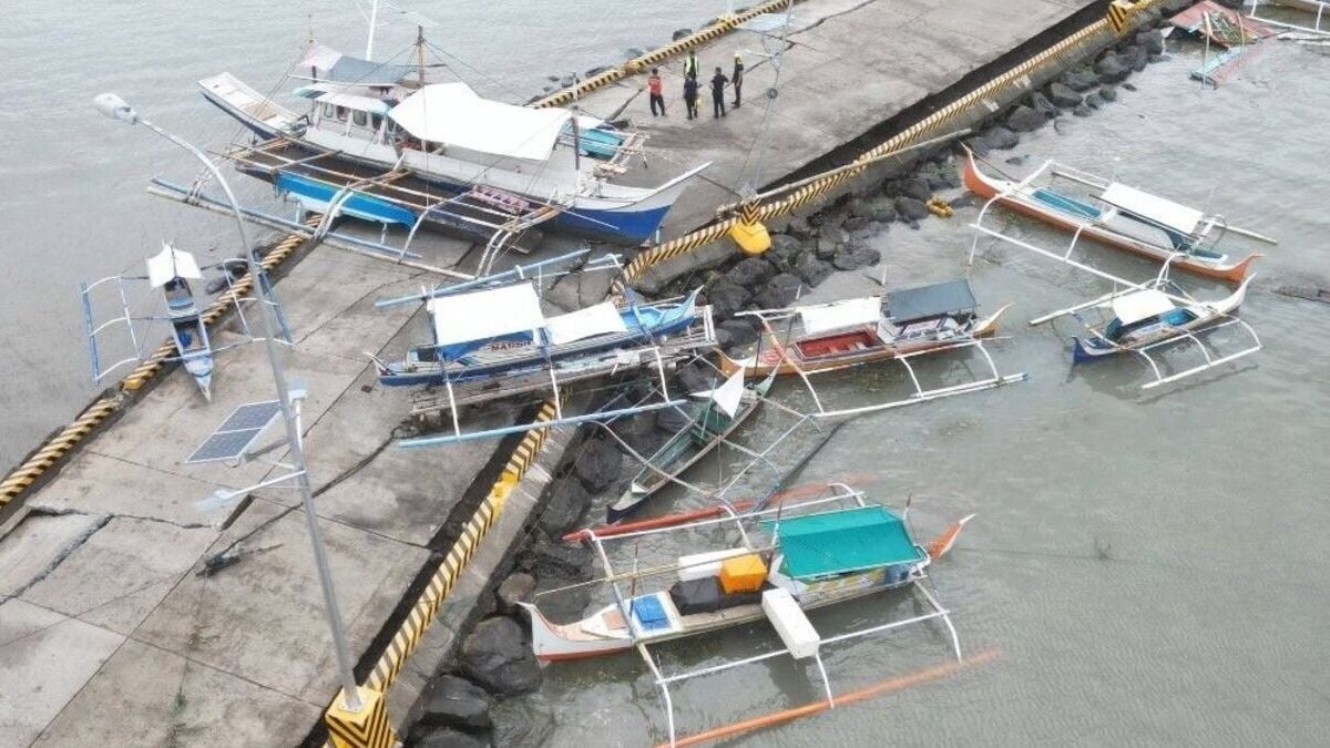
In the Philippines, the strongest shaking was reported in and around General Santos City, close to the earthquake’s epicentre. Buildings were damaged, power outages were reported, and emergency services were deployed as rescue and damage assessments continued.
Footage verified by the Guardian showed the upper floor of a Jollibee restaurant collapsing and concrete walls of a commercial complex giving way in General Santos City.
The Philippine national disaster agency earlier said at least 15 people had died, including 12 in the Soccsksargen region of Mindanao and three in Davao Occidental province. Later reporting by the Associated Press put the death toll at at least 16, with more than 200 people injured.
Schools had reopened for the new academic year on Monday when the earthquake struck. In Davao del Sur, part of a high school collapsed as students gathered outside, according to video shared by local media.
The Philippines Red Cross reported assisting students at several high schools after the quake. President Ferdinand Marcos Jr ordered the suspension of classes in affected areas until further notice, saying the safety of children came first.
Tsunami waves were detected in six areas within an hour after the earthquake struck off Sarangani on Monday morning. According to Phivolcs data as of 11 a.m., the first waves were recorded at: Maasim, Sarangani at 7:42 a.m.; Kiamba, Sarangani at 7:44 a.m.; Kalamansig, Sultan Kudarat at 7:59 a.m.; Mati City, Davao Oriental at 8:19 a.m.; Zamboanga City at 8:32 a.m.; and Tandag City, Surigao del Sur at 8:45 a.m. Phivolcs noted that tsunami activity was ongoing at these stations.
Phivolcs earlier issued a tsunami warning for nine coastal areas in Mindanao, including Sarangani, Davao Occidental, Tawi-Tawi, Sulu, Basilan, Zamboanga del Sur, Zamboanga Sibugay, Sultan Kudarat and South Cotabato.
Residents were advised to evacuate immediately, as the first tsunami waves could arrive between 7:37 a.m. and 9:37 a.m. and may continue for several hours. President Marcos also appealed to residents to follow the tsunami warning. “To our kababayans in the affected provinces, please heed the tsunami warning. Move to higher ground now. Do not wait. Your life is more important than anything left behind,” he said.
The Coast Guard District Southeastern Mindanao suspended all watercraft operations in Davao Occidental following the tsunami advisory, including fishing boats, passenger vessels and commercial watercraft.
Coastal monitoring and assessment operations continued, and the Philippine Coast Guard deployed personnel to assist with evacuations. Coast Guard spokesperson Commodore Noemi Cayabyab said fishermen and coastal residents were advised to secure their boats, move away from harbours and shallow waters, and that vessels already at sea should remain in deep waters.
Civil Defense Undersecretary Harold Cabreros identified Regions 9, 11, 12 and the Bangsamoro Autonomous Region in Muslim Mindanao as the areas most affected by the earthquake.
Evacuation operations were ongoing, and President Marcos directed members of the National Disaster Risk Reduction and Management Council and other agencies to go to affected areas to assess the situation.
In Indonesia, the Meteorology, Climatology and Geophysics Agency (BMKG) confirmed that small tsunami waves had been detected at multiple coastal observation points.
The first wave was recorded at Loloda, West Halmahera, North Maluku at 07.20 WIB, measuring 0.09 metres. Subsequent waves were observed at 07.27 WIB in North Sulawesi: 0.19 metres in Melonguane, Talaud Islands, and 0.18 metres in Ulu Siau, Sitaro.
Anomalies in sea level of 9–18 centimetres were reported at several points. BMKG said the waves remained relatively small but warned that the tsunami threat should not be considered over until authorities formally lifted the warning. Indonesia lifted its tsunami warning as of 1 p.m. local time.
BMKG officials urged the public to follow official information, remain calm but vigilant, and avoid approaching beaches or river mouths. Real-time monitoring continued through tide gauges and tsunami sensors across northern and eastern Indonesia.
Both Philippine and Indonesian authorities warned the public not to enter damaged buildings due to the risk of aftershocks. Residents were advised to rely only on official channels for updates.
The Philippines lies on the Pacific Ring of Fire and frequently experiences earthquakes and volcanic activity. Monday’s quake struck one of the country’s most disaster-prone regions and prompted warnings across several countries before the tsunami threat was later reduced in parts of the region.