Singapore's environmental studies keep finding reasons not to build. So why do we build anyway?
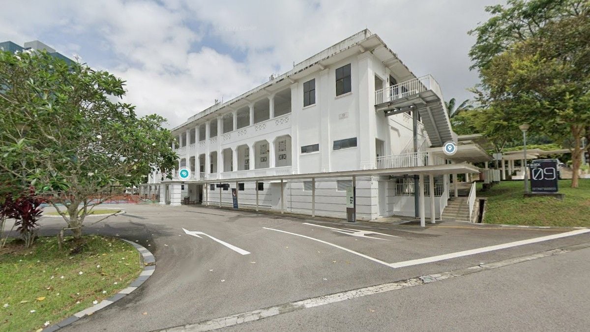
Singapore's environmental studies keep finding critically endangered species, mature forest streams, colonial-era heritage — and keep building anyway. Across Gillman Barracks, Maju Forest, Jurong and Woodlands, the same pattern repeats: EIAs document what will be lost, then explain how the loss will be managed, never whether the loss is necessary.

Read HDB's environmental impact assessments for Gillman Barracks and Sunset Way closely enough, and you start to wonder who they were written to convince.
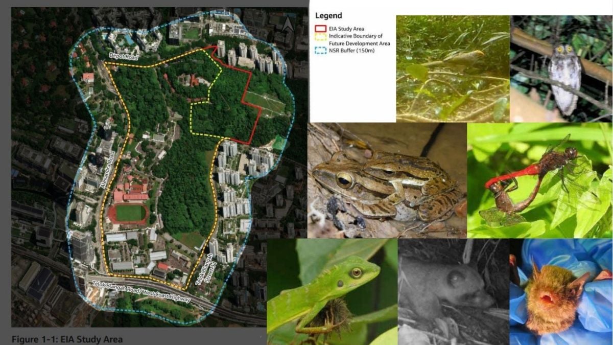
Sunset Way is HDB's project name; the forest underneath it is the one campaigners call Maju Forest, a regenerating secondary forest along the old Jurong railway corridor next to Clementi Forest. Both reports are HDB's own commissioned studies, both have been published for public feedback, and both arrive at the same place by different routes.
The Gillman report counts 293 plant species and 178 fauna species living on the site. Twenty-two of the plants and eleven of the animals are of conservation significance.
Among them: the critically endangered straw-headed bulbul, one of the rarest songbirds in Southeast Asia, and the bamboo bat, a species most Singaporeans will never knowingly see in their lifetimes.
The Sunset Way report, covering Maju Forest, records 286 flora and 113 fauna species, and confirms the presence of the Sunda pangolin — a creature so endangered it is one of the most trafficked mammals on earth — alongside its own population of the same critically endangered straw-headed bulbul.
These are not incidental findings buried in an appendix. They are the headline result of HDB's own due diligence, at both sites. Yet in the planning process as it has unfolded, the studies are used less as evidence to inform whether development should proceed than as evidence that its impacts have already been responsibly managed. That distinction — between deciding whether and deciding how — is what this entire episode turns on, and both reports demonstrate it in their own way.
The paperwork of destruction
HDB's pitch is reasonable-sounding, on the surface, at both sites. At Gillman: retain more than 20 of the 86 heritage buildings, keep most of the secondary forest and its stream, build ecological corridors at least 30 metres wide, preserve four heritage clusters. At Sunset Way: retain about 8 of the 23-hectare study area, including a freshwater stream and its riparian buffer, and call the rest "biophilic design."
But look at what survives the accounting and what doesn't. Six heritage buildings at Gillman cannot be saved. At Maju, of the 23-hectare study area, roughly 15 hectares — nearly two-thirds — will be cleared, against 8 hectares retained.
The "Save Maju Forest" petition, which has drawn more than 10,000 signatures, does not ask for zero development. It illustrates instead that Singapore still possesses substantial redevelopment opportunities before turning to mature forests — pointing to the Keppel Club site, slated to deliver about 9,000 homes on the Greater Southern Waterfront, a stone's throw from Gillman, as one example among several.
Read past HDB's summary and into the technical assessment of each report, and the same important distinction emerges twice.
At Gillman, using the report's assessment framework, the direct loss of native secondary forest — as distinct from exotic-dominated secondary forest or abandoned-land forest, the report's own categories — is assessed as Major Negative with a Certain likelihood, the highest significance assigned to any habitat type affected by the project. The distinction is even clearer in the report's own summary table:
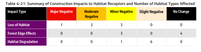
Loss of habitat is the only one of the three impact pathways that produces a Major Negative rating anywhere on the table, and it produces exactly one — native secondary forest.
Forest edge effects and habitat degradation, the two pathways HDB's mitigation measures are designed to address, register no Major Negative or Moderate Negative ratings at all.
By contrast, the mitigation measures highlighted in HDB's Gillman announcement — forest edge buffers, ecological corridors, retained woodland — primarily address forest edge effects and habitat degradation, impacts the same report assesses as Minor Negative for native secondary forest.
These are different impact pathways rather than contradictory findings. The proposed mitigation measures are intended to reduce impacts on the forest that remains.
The report's highest-rated impact, however, is the permanent loss of high-value native secondary forest through clearance itself.
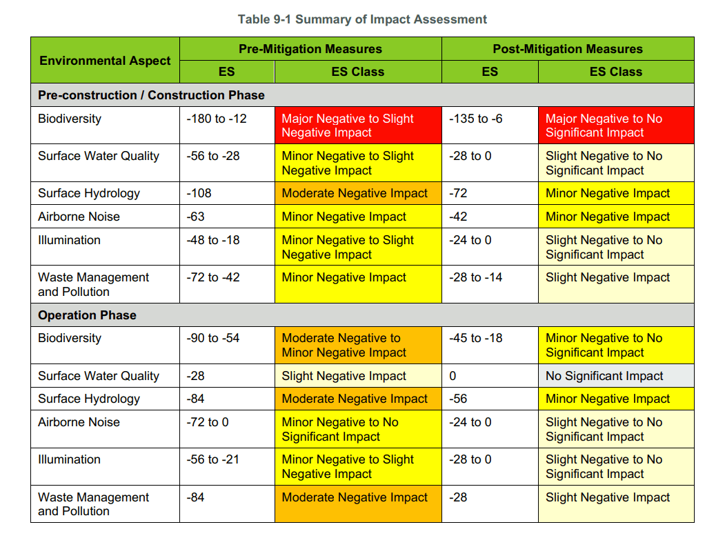
The Sunset Way report reaches an even starker version of the same conclusion. Its own line-item impact matrix rates native-dominated secondary forest as Major Negative before mitigation (environmental score -180) — and Major Negative after every recommended mitigation measure is applied (-135).
Unlike at Gillman, the classification for this habitat type does not move at all; mitigation only reduces the score within the same worst-case category.
Other line items on the same table do improve categorically — avifauna, the category that explicitly notes "the globally Critically Endangered Straw-headed Bulbul was recorded," moves from Major Negative to Minor Negative once mitigation is applied, and the site's waterbodies move from Major Negative to Slight Negative.
But the report's own conclusion section states the headline number plainly: for the pre-construction and construction phase, biodiversity impact ranges "Major Negative to Slight Negative" before mitigation and, after every measure proposed, still ranges "Major Negative to No Significant Impact." Major Negative remains part of the range HDB's own consultants signed off on, after mitigation, in the report's own summary table.
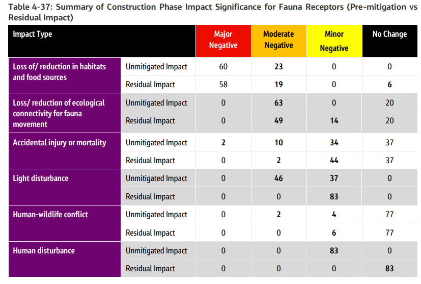
 Gillman's report goes one step further and shows what its mitigation actually achieves at the level of individual species, because it publishes a before-and-after comparison.
Table 4-37 sets out the impact significance for fauna species before mitigation and again as a "residual impact," once the Proposed Retained Area, ecological corridors and other measures are factored in. For "loss of/reduction in habitats and food sources" — the pathway tied to actual clearance rather than edge effects — 60 species are rated Major Negative before mitigation.
After every proposed measure is applied, 58 species remain rated Major Negative. Only two species, the square-tailed drongo-cuckoo and the keel-bellied whipsnake, are downgraded to Moderate Negative. The other 58 are unmoved.
The Gillman report points to one reason those two assessments differ. It notes that 97.26 per cent of native-dominated secondary forest by area is retained, sufficient to downgrade the habitat-level assessment for loss of habitat from Major Negative to Moderate Negative.
Yet retaining most of the habitat by area does not necessarily preserve the ecological functions individual species depend on — connectivity, forest-interior conditions, or specialised microhabitats. That is consistent with why the habitat-level assessment improves while, for most fauna species, the residual impact does not.
The clearest illustration comes from flora rather than fauna. The critically endangered Symplocos adenophylla, represented by a single recorded specimen on the Gillman site, remains assessed as Major Negative after mitigation because the report concludes it is "very unlikely" to be salvaged and "will instead be felled." Mitigation was considered. For this specimen, the report concludes it will not change the outcome.
None of this means mitigation is meaningless — flora mortality at Gillman overall falls from 12 species Major Negative to 1 after salvaging measures, a substantial and genuine improvement, and it would be unfair to either report not to say so.
But the pattern across both sets of tables is consistent: mitigation works well on effects that radiate outward from clearance, and works far less well on the clearance itself.
Taken on their own terms, both reports function as documents for identifying impacts, recommending mitigation where practicable, and recording the residual impacts that remain after those measures are applied.
What is striking is not that they hide what cannot be mitigated, but that they document those limits in considerable detail — at Gillman down to individual species, at Sunset Way in the executive summary itself.
A further complication deserves mention. Although both reports state that they use the same Modified Rapid Impact Assessment Matrix framework, they operationalise biodiversity differently.
Gillman presents categorical impact ratings derived from a simplified ecological-value matrix, while Sunset Way publishes the underlying environmental scores for each receptor. The category labels — Major Negative, Moderate Negative, and so on — are the same, but the path to those labels is not.
That does not invalidate either report, but it does mean direct numerical comparisons between the two are difficult, despite both informing housing projects announced on the same day.
What is an EIA actually for?
That brings us to the question neither report can answer. If an environmental impact assessment documents impacts that remain significant even after every practicable mitigation measure has been applied, what role should that finding play in deciding whether a project proceeds at all? Is an environmental impact assessment meant to inform whether a site should be developed at all — or only how the damage is distributed once development is already decided?
Singapore's own parliamentary record answers this more clearly than any campaign literature could. In February, Member of Parliament Dennis Tan asked the Ministry of National Development whether it would adopt a biodiversity metric like the United Kingdom's Biodiversity Net Gain framework — a system that requires developments to demonstrate measurable ecological improvement, not merely mitigation.
Minister of State Alvin Tan's reply was instructive: the UK's approach imposes "targets on individual development projects," he said, whereas Singapore prefers "a balanced and coordinated approach."
Pressed with a follow-up question that raised the point again — including a direct ask about adopting the UK's mandatory 10 per cent net-gain baseline — he still did not commit to any quantitative benchmark. He offered LUSH's 440 hectares of greenery instead — a measure of provision, not of ecological gain or loss.
The pattern holds well beyond Gillman and Maju. When JTC's environmental impact assessment for the CleanTech Park and Bahar precincts in Jurong found ecological value worth safeguarding, Deputy Prime Minister Gan Kim Yong's written reply to Parliament in February did not explain why 52 hectares of forest could not be preserved in full.
It listed mitigation measures instead: "retention of forested areas with higher ecological values, transplanting plant species of conservation significance and implementing wildlife management." The question of alternative sites went unaddressed.
When Woodlands forest came up for clearance the same pattern repeated almost verbatim — an EIA "to assess and recommend measures to mitigate potential environmental impact," never one asked to weigh whether the clearance should happen.
Three different sites, spanning two ministries and two statutory boards, the same template each time: identify what will be lost, then explain how the loss will be managed. What the responses do not do is compare that choice against alternative sites or explain why the identified ecological loss is unavoidable.
If an assessment documenting critically endangered species only ever changes where a corridor is drawn, and never prompts reconsideration of whether a site is developed at all, then the assessment functions less as a decision-making tool than as a mitigation exercise.
In planning terms, these are fundamentally different functions. One is a screening question: should this development proceed here at all? The other is a mitigation question: given that it will proceed, how should the impacts be reduced? Singapore's EIAs, on the evidence above, appear to operate almost entirely in the second category.
To be fair to the Government's position, Singapore's land scarcity is real, and few countries manage competing land uses under comparable constraint. The record also shows that "mitigate" is not always the final word.
Plans for the Cross Island MRT Line were pushed to tunnel more than 70 metres beneath the Central Catchment Nature Reserve, eliminating surface works entirely, after ecological studies flagged the risk to the reserve.
Dover Forest's eastern half was cleared but its western half kept whole as a nature park, after 2020's public outcry. Clementi Forest was shelved indefinitely.
The mudflats at Mandai were dropped from development altogether and protected as a nature park once surveys showed their importance to migratory shorebirds.
So preservation is not, in fact, impossible within this system. It has happened, more than once, when public pressure was sustained enough. Which raises the real question for Gillman and Maju: why is "modify at the margins" the default posture, requiring petitions and feedback campaigns to shift it even slightly, rather than something closer to Mandai's outcome being on the table from the start?
The buildings nobody proposes to clear
There is a second, quieter inconsistency worth sitting with. If land in this corner of Singapore is scarce enough to justify clearing a mature forest with a critically endangered bulbul in it, why does the plan simultaneously commit to retaining more than 20 colonial-era buildings — structures most Singaporeans will visit rarely, if ever, and which will house a comparatively small number of "future commercial and community uses" rather than family homes?
This is not an argument for demolishing Gillman's heritage buildings; the point cuts the other way. It shows that "we need every hectare" is not, in fact, the operating principle.
Land is being allocated according to a hierarchy of value — heritage clusters are worth preserving even at some cost to housing yield, a running track and an archery club's lease are treated as negotiable. Somewhere within that hierarchy sits a judgement that part of the mature forest is more expendable than the heritage cluster retained around it. HDB has not been asked, in public, to explain that ordering. It should be.
Gillman is not the only example of land that sits largely outside Singapore's usual land-scarcity debate. The Republic's roughly 500 state-owned black-and-white bungalows occupy generous plots that are rarely discussed in terms of redevelopment, despite being public land.
The median plot measures about 38,000 square feet — roughly the footprint of 35 typical four-room HDB flats. Most are rented out on two-year tenancies to affluent households, expatriates and foreign missions rather than used for housing at scale.
In February this year, the Singapore Land Authority tendered a 30-year lease over 19 black-and-white bungalows across 12.8 hectares at Adam Park for conversion into serviced apartments. The policy debate centred on adaptive reuse rather than whether the land itself represented an inefficient allocation of scarce space.
To be fair, the comparison is not exact. Many black-and-white compounds fall under NParks' Heritage Road and Heritage Tree schemes because their mature rain trees and established canopy carry genuine ecological value, not merely architectural or historical significance. Mount Pleasant Road, which runs through one such cluster, is itself a designated Heritage Road.
But that similarity is the point rather than a rebuttal. If ecological value is recognised when it surrounds a colonial bungalow, yet a nearby secondary forest containing a critically endangered straw-headed bulbul still has to justify its survival through an environmental impact assessment before redevelopment proceeds, then the inconsistency is not simply heritage versus nature. It is about which landscapes begin from a presumption of protection and which begin from a presumption of redevelopment.
That is why the recurring debate over forests can feel strangely one-sided. The question is almost always whether the woodland is valuable enough to save, seldom whether other uses of equally scarce public land remain the best use of that land. Environmental impact assessments end up asking nature to prove its worth, while other landscapes are rarely asked to do the same.
Who, exactly, is this housing for?
HDB says the Sunset Way development responds to "strong demand for homes, driven by factors such as marriage and family formation."
Singapore's total fertility rate hit a fresh historic low of 0.87 in 2025, and marriage rates continue to fall — trends the Ministry of Social and Family Development's own reports document.
That does not, on its own, prove housing demand is falling; household size, divorce, later marriage and upgrading all move independently of the birth rate.
But it does mean the specific explanation HDB has offered looks increasingly incomplete as the sole driver of a pipeline this size, and that gap matters most for a development timed against a moving target: residents will not move in until well into the next decade, by which point Singapore will be sitting at or near the Government's own 2030 planning parameter of 6.5 to 6.9 million, with no year specified for when that intake tapers.
If demand increasingly depends on factors beyond marriage and family formation, the Government should say so, and let that fuller explanation be weighed during public feedback, not assumed away by omission.
The consultation that isn't
HDB will say, correctly, that the feedback period runs until 6 August, and that findings from environmental and heritage studies "together with public feedback" will shape final plans. Fair enough — but Singaporeans have been here before.
Dover Forest is proof engagement can move outcomes. It is also proof that the starting position is always maximal clearance, adjusted downward only under sustained public pressure — never designed with restraint from the outset, the way Mandai's mudflats were.
The Maju petition put it better than I can: "The forest cannot speak at a consultation. The pangolin cannot sign this. The bulbul can only sing. So we must."
That is not activist theatre. It is an accurate description of an asymmetric process, where the party with the least power — a fragmented ecosystem that cannot be rebuilt once cleared — gets a single feedback form and a six-week window against an agency with survey teams, planners and Ministerial backing.
A false choice, not a necessary one
The consultation process begins after the site has already been selected for development. The only remaining question on the table is how much ecological or heritage loss is acceptable. It never asks whether another design, another site, or another configuration entirely could deliver the same housing outcome with less irreversible loss.
Clearance and preservation are presented as the only two configurations seriously on offer — forest or flats, heritage building or housing yield, never both at once. That framing treats one planning solution as though it were the only one available, and other cities have already demonstrated otherwise.
New York's Landmarks Preservation Law gives its preservation commission the power to refuse alterations to a designated landmark outright — a power the US Supreme Court upheld in 1978 when a developer tried to build an office tower directly above Grand Central Terminal.
The principle that ruling established was simple: a city can require new development to work around a protected site rather than through it, and require the developer to design for that constraint from the outset rather than negotiate it away afterward.
The more applicable case for a sprawling, low-lying site like Gillman is the Villard Houses on Madison Avenue: a low, U-shaped cluster of nineteenth-century mansions that a 1970s developer wanted to raze for a hotel. Instead, the mansions were kept whole, their courtyard and front rooms preserved as the building's grand entrance, while a 55-storey tower — now the Lotte New York Palace — was built up and back behind them. The low heritage structures and the highrise now share the same footprint. Nobody had to choose.
None of this is cheap, and Singapore is not New York — a forest is not a facade, and there is no market in unused "ecological floor area" to trade. But the principle transfers even where the mechanism doesn't: the burden of proving coexistence is possible sits with the developer, not with the public having to petition for a fraction of a mercy after the tender is already called. Singapore's process runs the opposite way.
Once a site has been identified for housing, HDB commissions the EIA, and only then negotiates how much of the forest or the heritage cluster to spare — with the public expected to supply the pressure that forces any further concession. If a critically endangered pangolin's habitat, or a colonial garrison's stream and canopy, is worth building around rather than through, that should be the design brief from day one, not a mitigation measure extracted six weeks before the tender closes.
What that would look like in practice: exhaust the brownfield sites and underused land first, before touching what cannot be regrown. Publish the full environmental studies before any tender is called, not after. Protect the Maju-Clementi corridor as a matter of policy, not goodwill.
And, at minimum, adopt something like the UK's Biodiversity Net Gain benchmark that MP Dennis Tan proposed in February and the Government declined — not because Singapore must copy another country's framework wholesale, but because "we will assess impact and manage it" is not the same commitment as "we will not proceed unless the outcome is net positive," and Singaporeans deserve to know which of the two they are actually being offered.
It may well be that this is exactly what an EIA is designed to do under Singapore's planning framework — that its intended role has always been mitigation, not project approval. If so, the public should be told that plainly, because it changes what a feedback exercise can realistically achieve.
Singaporeans may reasonably expect EIAs to help determine whether development should proceed at all. In practice, they appear to function primarily as tools for mitigating impacts once that decision has already been made. Those are different functions, and they create different expectations about what a consultation can realistically deliver.
Gillman Barracks and Maju Forest are not renewable resources. HDB's own scientists have told us exactly what is at stake, in exhaustive, credible detail. The question worth asking is not whether the environmental impact assessment was thorough. It clearly was.
The question is why thoroughness has, so far, changed nothing about the outcome — and why, across Jurong, Woodlands, Gillman and Maju alike, the answer to "what did the EIA find" is always followed by a mitigation plan, never by a reconsidered decision.
An environmental impact assessment should not only tell us how to minimise ecological damage. It should also be capable of changing the decision to proceed at all. If it never does, then the assessment is informing mitigation, not the decision itself — and Singaporeans are entitled to ask which one they have actually been given a say over.